

§ 34-6. General standards for residential or duplex development on individual lots.
(a)
Stormwater management plan applicability . Stormwater management requirements shall apply to the following types of development:
(1)
New detached single-family and duplex residential properties.
(2)
Existing single-family and duplex residential properties where more than 500 square feet of new built-upon area is being added. In such cases, the stormwater management requirements shall apply only to the new built-upon area.
(3)
Removal and replacement of driveways. In instances where an existing driveway and parking area not meeting the standards of this section is being removed and replaced, the new driveway and/or parking area shall be designed so as to limit the discharge of stormwater into the right-of-way or onto adjacent properties.
(b)
Stormwater management standards.
(1)
All runoff from the project's built-upon area shall be directed into an approved stormwater management system designed with a storage volume of 15 cubic feet for every 100 square feet of built-upon area.
(2)
Stormwater control management (SCM) measures may include a variety of techniques used in combination to achieve the storage volume requirement. These include:
a.
Rainwater harvesting to include cisterns and/or rain barrels;
b.
Subsurface drainage systems to include dry wells, french drains and infiltration galleries/panels;
c.
Permeable pavements;
d.
Tree/open space preservation credits;
e.
Bioretention or rain gardens;
f.
Landscaped swales;
g.
Infiltration basins;
h.
Other methods as approved by the stormwater administrator.
(3)
Guidance for applying and calculating the techniques listed above can be found in the Town of Nags Head Recommended Standard Details Manual.
(4)
On-site permanent runoff control measures shall be installed, in conjunction with other on-site stormwater management practices, to intercept rainfall runoff from driveways that are sloped or graded towards the street or right-of-way. On-site permanent runoff control practices include, but are not limited to, permeable pavement ribbons, slotted drains, driveway speed bumps or other approved methods of diverting, collecting and managing on-site runoff. Measures to control runoff from driveways may be combined with other stormwater management techniques to meet the stormwater volume requirement.
(5)
In no instance shall open drainage systems be located beneath a building.
(6)
Storage capacity (interstitial storage) within existing soils and/or fill material shall not be counted towards the volume requirement for the stormwater management design.
(7)
Reduction of built-upon area. Certain stormwater management practices are encouraged and shall reduce the site's built-upon area in accordance with the following standards:
a.
Paved surfaces which are designed to be permeable in accordance with the Town of Nags Head Recommended Standard Details Manual or as otherwise approved by the stormwater administrator shall not count as built-upon area.
b.
The water surface area of pools, wood slatted decks, and non-compacted, clean gravel and stone areas shall not count as built-upon area.
c.
Preservation and/or planting of vegetation shall reduce built-upon area in accordance with the following schedule:
1.
Existing trees receive a 100 square foot reduction in built-upon area (min. six-inch caliper).
2.
New trees receive a 50 square foot reduction in built-upon area (min. two-inch caliper, min. six-foot tall).
3.
Trees must comply with list of approved species included in the town's vegetative planting guidelines.
d.
Projects that reduce the overall limits of disturbance and designate areas of preserved open space shall receive a reduction in built-upon area.
1.
Open space areas and the credit for the reduction of built-upon area shall be calculated at a 2:1 ratio. For example, for every two square feet of preserved open space, built-upon area shall be reduced by one square foot.
2.
There shall be a minimum of 1,000 square feet of preserved open space to qualify for this credit. Individual pockets or areas of preserved open space shall be a minimum of 250 square feet in area.
3.
Preserved open space shall not be applied in areas of the lot that are typically excluded from development including wetland areas, ponds, or areas that are excluded from development by other agencies.
4.
Preserved open space shall contain significant examples of locally adaptive and/or native trees and/or shrubs and shall be located in areas that create natural vegetative filtering or retention between built-upon areas and adjacent properties or rights-of-way.
e.
Total tree credit and/or open space preservation credits in combination shall not reduce total built-upon area by more than 30 percent.
f.
Projects that incorporate three or more of the stormwater control measures listed in subsection (b)(2) above shall receive a 15 percent built-upon area reduction. This reduction shall be applied in addition to the built-upon area reductions already provided by this section.
(8)
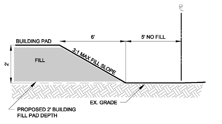
Fill shall not be placed within five feet of a property line, except for the grading of driveway entrances, such that runoff from a fill slope is not "pitched" onto adjoining properties. A maximum of a 3:1 horizontal to vertical fill slope shall be maintained. Setback area may be used to accommodate an approved stormwater control measure. See Diagram 34-A.
DIAGRAM 34-A: SETBACK REQUIREMENT WHERE FILL IS USED
(9)
The five-foot setback requirement may be varied or waived as part of a multi-lot development of contiguous properties, or between adjacent properties if and only if a dedicated easement is established to accommodate a shared drainage swale or other SCM between adjacent properties as approved by the town engineer.
(10)
The construction and use of bulkheads, walls, and other structural controls to retain the placement of fill on property shall only be permitted:
a.
In the immediate area of the on-site sewage disposal system as approved by the Dare County Health Department for the installation of such system, or
b.
In those areas of the property where the naturally occurring slope exceeds 3:1 or greater in steepness, or
c.
In those areas of where a retaining wall is necessary to achieve a five-foot setback of fill from an adjacent property boundary. Retaining walls used on fill slopes shall not be tiered, shall not retain more than two feet of fill, and shall not exceed two feet in maximum height from final grade.
(11)
The allowable depth or elevations for fill are in subsection (c) of this section.
(c)
Standard for depth or elevation of fill. Any residential or duplex development or redevelopment which utilizes fill shall be limited to the following standards according to the zone as designated on the most recent flood insurance rate maps or FIRM.
(1)
Within the Oceanfront V Zone:
a.
Addition of landscape fill is permitted up to two feet above the pre-development surface grade or up to base flood elevation, whichever is lower;
b.
Fill footprint may not exceed ten percent of the lot area (see sections 48-402, 48-403, 48-404, 48-405 dimensional requirements), excluding the footprint of the active drainfield and septic system as approved by the health department in accordance with the septic permit. Lot area is defined as that portion of the lot landward of the first line of stable vegetation as defined by CAMA;
c.
No bulkheads are allowed;
d.
All grading and fill activities must comply with guidance provided in FEMA Technical Bulletin #5.
(2)
Within the Estuarine V Zone:
a.
Addition of fill is permitted but shall not exceed the base flood elevation.
b.
Fill footprint may not exceed 50 percent of the total developable lot area (see sections 48-402, 48-403, 48-404, 48-405 dimensional requirements) as defined by CAMA, excluding:
1.
The footprint of the active drainfield and septic system as approved by the health department in accordance with the septic permit; and
2.
Backfill used as part of a CAMA approved estuarine bulkhead and placed within 25 feet of the bulkhead structure.
(3)
All other flood zones (including AE and X): Fill shall not be permitted to exceed base flood elevation except in cases where it is placed directly beneath a slab that is designed to meet the regulatory flood protection elevation as defined in town Code section 22-32. In these instances, fill may exceed the base flood elevation by up to 12 inches to support a turn-down or thickened edge slab or beneath a slab that is supported by a ring-wall style foundation. Fill placed above the base flood elevation shall not extend beyond the outside edge of the slab. In areas in which there is no base flood, fill shall not exceed the amount required for wastewater permits required by the Dare County Health Department, or two feet above pre-development surface elevation, whichever is higher.
(d)
Plan submittal, review and approval for residential or duplex development on individual lots. It is the responsibility of an applicant to provide sufficient information in the plan so that the town or its agents may reasonably evaluate the environmental characteristics of the affected areas, the potential and predicted impacts of the proposed activity on area surface waters, and the effectiveness and acceptability of those measures proposed by the applicant for reducing adverse impacts. The applicant shall provide, as necessary, maps, tables, photographs, narrative descriptions and explanations to demonstrate compliance with the town's stormwater management standards.
(1)
The stormwater management plan shall be submitted as part of the application for a building permit or land disturbance permit.
(2)
The stormwater management plan need not be prepared by a registered design professional. However, the town will consider plans and additional alternatives to meet the stormwater requirements if prepared by a registered design professional. An on-site meeting with the stormwater administrator or his/her designee is strongly encouraged prior to plan preparation.
(3)
The stormwater management design information may be depicted on a site survey that is also utilized for zoning, CAMA, or other town approvals. At a minimum the plan shall include:
a.
Existing conditions. The conditions of the site shall be described in general, including the following:
1.
The direction of flow of stormwater runoff under existing conditions.
2.
The location of areas on the site where stormwater collects or infiltrates into the ground.
3.
A survey of the site, including topography. The survey shall be prepared by a licensed surveyor and shall include the minimum required elevation information as referenced in the Town of Nags Head Recommended Standard Details Manual. The survey must also show the location of drainage ditches within the area surveyed, and the location of wetlands and ponds.
4.
Approximate elevation of seasonal high-water table. "Seasonal high wetness condition" as indicated by the Dare County Health Department site evaluation is acceptable for determining vertical separation compliance of SCMs on single-family and duplex residential projects. Also, include any fill requirements provided with the Dare County Health septic approval.
b.
Proposed alterations. Proposed alterations of the site shall be described, including:
1.
Change(s) in topography. The proposed final elevations shall be shown in a manner that can be distinguished from the existing elevations. If there are abrupt changes in elevations, these should be clearly identified in the plans. These should be plotted on a scale that is easy to read and in a form that conveys the nature of changes that are proposed.
2.
Identification and quantification of the area(s) that will be covered with built-upon area and a description of the surfacing material(s).
3.
The proposed area to be preserved and/or planted with vegetation as well as any designated open space. This shall include the location of any trees and/or open space that will be utilized to reduce the built-upon area calculations.
4.
Identification and quantification any other site improvements such as pools, wood slatted decks, and permeable pavement.
5.
The size and location of any buildings or other structures, including bulkheads or retaining walls.
6.
Stormwater runoff features. All SCMs intended to receive stormwater runoff from the proposed built-upon areas on the site shall be described and their location identified on the survey.
7.
Erosion and sediment control measures. A description of the measures that will be put in place for the control of erosion and sedimentation shall be provided.
8.
Other information. The applicant shall provide other information which the town or its designated agent deems necessary for an evaluation of the development proposal for compliance with this chapter.
(4)
Elevation data shall be provided on the as-built survey to determine compliance with the maximum fill height requirements of this chapter.
(5)
Upon completion of stormwater management improvements, the stormwater administrator or his/her designee shall verify compliance via field inspection. Once a project is completed, stormwater management features shall be maintained in accordance with the approved plan and subsequent certificate of compliance.
(Ord. No. 15-06-016 , Pt. I, 6-3-2015; Ord. No. 15-10-035 , Pt. II, 10-7-2015; Ord. No. 17-12-020 , Pt. I, 12-6-2017; Ord. No. 18-12-017 , Pt. II, 12-5-2018)